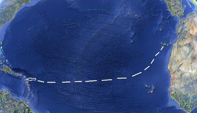
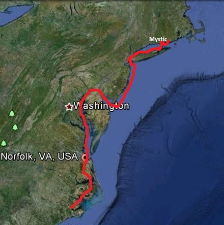
Our approximate route
The boat is provisioned, the chores are done, and we have explored our 4th Canarian Island. So we think the time has come to head west. On the map is an approximate path, but of course it will change depending on the wind and weather. Right now, we are planning to go directly to Saint Martin, but we may decide to stop in the Cape Verde Islands if the trade winds are not settled enough. We won't be keeping up this blog at sea—no internet out there for us!—so you can check on our progress by going to YOTREPS. The address is http://www.pangplin.co.nz/yotreps/reporter_list.php Our boat will appear on the first page under my ham call sign AB0T with the boat name Cormorant beside it. Click on it and a google map of our latest location will come up, along with a very brief note about how we are doing. The total distance is just over 2800 miles, and it should take us around 3 weeks. Keep writing us your news along the way for sure. Some we can get at sea and the rest will be a very big welcome back to the Americas for us when we reconnect. So please do write; send those Christmas letters.
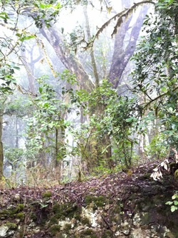
Cloud forest, La Gomera
We have been here in La Gomera since Monday, and we are very glad we decided to stop here. It is really still a very local place, with tourism an important part of the economy, but no big group tour hotels, no international airport, and no English grocery stores. People are Canarian and they speak Spanish. We spent one day riding the bus across the island and also rented a car for a day with other cruisers. No volcanic activity has occurred here in over 2 million years, but the island is circular and still looks like a large single cone, but with dramatic cliffs and valleys created by erosion. In the center, at the top of the island, is a large national park with forests of laurel and related species in the cold cloud forest. It is wet all the time, with lots of lichens, mosses and ferns along with the local pines, laurels, and small spruce looking trees. One of the major activities here is hiking, but we contented ourselves with the bus and car. The hikes are steep and slippery, so we opted to preserve our bones and muscles for the crossing. No "Bataan death marches" this time.
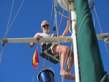
Harry aloft
Today is full of all the last minute jobs. I did three buckets of wash this morning, enjoying the luxury of unlimited water out of a hose (no laundromat here ) Harry has been up the mast to check all the shrouds and blocks and lube the mainsail track. Now he is making a new antenna for the AIS because the one we have is in the way of the wind steering sail when we go downwind—which we will on this passage. Tomorrow morning we'll make a quick trip to the market for fresh apples, carrots, mangos and avocados. Then we'll be off.
Don't forget to write, please. Use the same address you always do, and we will get it.
Don't forget to write, please. Use the same address you always do, and we will get it.
 RSS Feed